
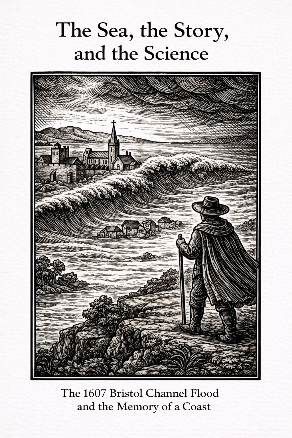
The Sea, the Story, and the Science
This essay is free to read here and free to download as a PDF or EPUB.
Introduction
It started, as these things often do, with a passing comment.
A friend mentioned a book — The Downed City by K.J. Maitland — and within it, an extraordinary claim. In 1607, they said, a tsunami struck the Bristol Channel. Whole communities were drowned. Churches flooded. Houses swept away.
A tsunami.
The word sits uneasily beside English shores. We tend to imagine distant tectonic violence, Pacific horizons, warning sirens and fractured coastlines. Not Somerset fields. Not the Severn Estuary. Not the flat land between Weston and the Mendips, where river, road, and sea sit closer together than we sometimes notice.
And yet, the event itself is not in doubt.
On 30 January 1607 (by the modern calendar), water surged deep into low-lying land around the Bristol Channel and Severn Estuary. Contemporary accounts describe villages overwhelmed, livestock lost in their thousands, homes collapsing under sudden force. In Kingston Seymour, a church still bears a record of that water. In parish registers, names appear — abruptly, without ceremony — marking lives cut short.
Some have described it as a tsunami.
Others point instead to an extreme storm surge, driven by wind, tide, and geography.
Four centuries later, we have the advantage — and perhaps the responsibility — of perspective.
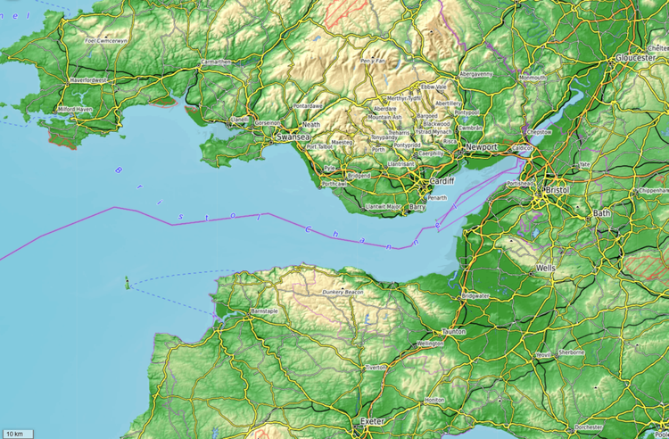
The Bristol Channel is no ordinary stretch of water. It narrows as it moves eastward. Its tidal range is among the highest in the world. When Atlantic swell, spring tide, and fierce winter storms coincide, the sea does not simply rise. It accelerates. It concentrates. It amplifies.
Stand on the Weston sea wall during a winter gale and you can feel that dynamic at work. The waves do not merely break against the shore; they are driven inward, shaped by coastline and depth.
So the question becomes less romantic, and more interesting:
Did a tsunami strike England in 1607?
Or did the sea, governed by gravity and wind, behave in a way that felt like one?
This is one of those rare moments where physics and folklore intersect.
Because whatever the cause, the experience for those living through it would have been the same.
Water where there should not be water.
Fields turned to sea.
Ground made unstable.
Families seeking higher ground.
And as we look closer — not for spectacle, but for understanding — something else begins to emerge. Not only what happened, but how it was remembered. How language shapes memory. How explanation can become legend. And how, even now, we still expect someone else to hold back the tide.
I do not write about events like this to declare a verdict. I am not claiming certainty, nor dismissing those who see it differently. Stories — especially dramatic ones — tend to settle into comfortable forms. “Tsunami” is powerful. It captures attention. But power is not the same as accuracy.
If there is a quieter explanation — one shaped by geography, tide, and timing — then it is worth exploring together. Not as a correction, but as a conversation. One that invites others to question, to research, to challenge, and to share what they find. Because memory, like the tide, moves only if we keep it moving.
So let’s step closer to the edge.
Not to the moment the water arrived.
But to the land before it did.
Winter on the Somerset Levels, January 1607
Before the word tsunami ever entered the conversation, there was only land.
Low, flat land stretching beneath a wide winter sky.
Fields divided by hedges and ditches. Narrow rhynes guiding water toward the Parrett and the Axe. Cattle clustered against the wind. Smoke lifting thinly from thatched roofs.
The Somerset Levels in January 1607 would not have looked dramatic. They would have looked ordinary — working land shaped by generations who understood both its richness and its risk.
This was reclaimed ground. Managed ground.
Marsh turned productive through drainage and labour. The people who lived here did not fight the water outright; they lived with it. Their livelihoods depended upon it. Sheep grazed on drained pasture, their wool feeding looms and fulling mills. Dairymen relied on grass that grew thick on former marsh. Fishermen worked tidal creeks. Farmers trusted embankments to hold while winter rain filled the rhynes that cut across the fields.
They knew winter brought storms. They knew spring tides could test embankments. None of this was unfamiliar.
It was home.
Among those homes — and along the wider shores of the Bristol Channel — were households like that of James Ffroste of Barnstaple, on the Devon side of the water. Barnstaple was no isolated hamlet. It was a working port town, tied to trade, river traffic, and the textile industry that shaped much of the region’s economy.
We do not know his face, the colour of his coat, or the sound of his voice. But we know enough to situate him in that landscape.
He was not destitute. Parish records describe him as a “toaker” — a tucker, a cloth finisher — part of the labour that turned raw wool into finished cloth. It was work that depended on water, but controlled water: washing, fulling, rinsing, managed within riverbanks and vats.
His livelihood, like that of so many along the Channel, depended on structures holding and water remaining within its usual channels.
Water was part of his trade. It was not meant to be his destroyer.
The church tower would have stood visible across the fields, a constant vertical in a horizontal world. The rhythms of parish life — baptisms, burials, markets, shared labour — tied households together. Disaster, if it came, would not be isolated.
And yet, on that January morning, nothing in the landscape would have announced what was about to happen.
Contemporary reconstructions suggest storm conditions in the Bristol Channel. The Atlantic in winter is rarely calm. Storms were not unusual. Gales did not automatically signal catastrophe.
If you stood on slightly higher ground and looked westward, you would have seen the open Channel — wide, distant, almost detached from the inland fields. The sea was something over there. Present, but separated by miles of low coast and marsh.
Until it wasn’t.
When the water came, it did not creep. It did not politely fill ditches and pause. Accounts from 1607 describe sudden force — a surge driving inland with speed.
On land as flat as the Levels, speed decides everything.
Water moving quickly does not simply rise; it undermines. It tears at foundations. It saturates and shifts. A house of timber frame and wattle-and-daub, even when well built, depends on stable ground. If that ground is scoured or destabilised, the structure does not float.
It fails.
The parish register records the death of James Ffroste and his two children. It notes that his house fell down upon them.
That detail matters.
It suggests structural failure under flood conditions — foundations compromised, walls unable to bear shifting load. Not a building carried whole out to sea, but one overwhelmed from beneath.
Further east along the Bristol Channel, in Somerset, the human cost was recorded more collectively. Contemporary accounts speak of twenty-eight drowned at Huntspill, twenty-six at Brean, and widespread destruction along the low-lying coast and Levels. Parish registers confirm burials in the weeks that followed, though without the descriptive memoranda found in Barnstaple.
The names are there — in ink that has not faded — but they require deeper archival work to bring fully into view.
Disaster does not erase people. It obscures them.
And for those living on the low land of the Channel, the margin between difficulty and devastation could lie in minutes.
Water where fields had been.
Livestock swept from enclosures.
Families scrambling for higher ground — church towers, upper rooms, embankments.
And afterwards: silence. Debris. Mud. Loss.
It is easy, four centuries later, to step in with terminology. To argue whether this was a tsunami or an extreme storm surge amplified by tide and geography.
But before we apply labels, we must sit for a moment in 1607.
On land that had always required management.
Among people who believed they understood its risks.
Watching the sea behave in a way they had never seen before.
Only then does the question become meaningful:
What kind of force could do this?
The Shape of the Sea — And the Timing of the Tide
If we step back from the language of catastrophe and simply ask how water behaves, the 1607 flood becomes less mysterious — though no less serious.
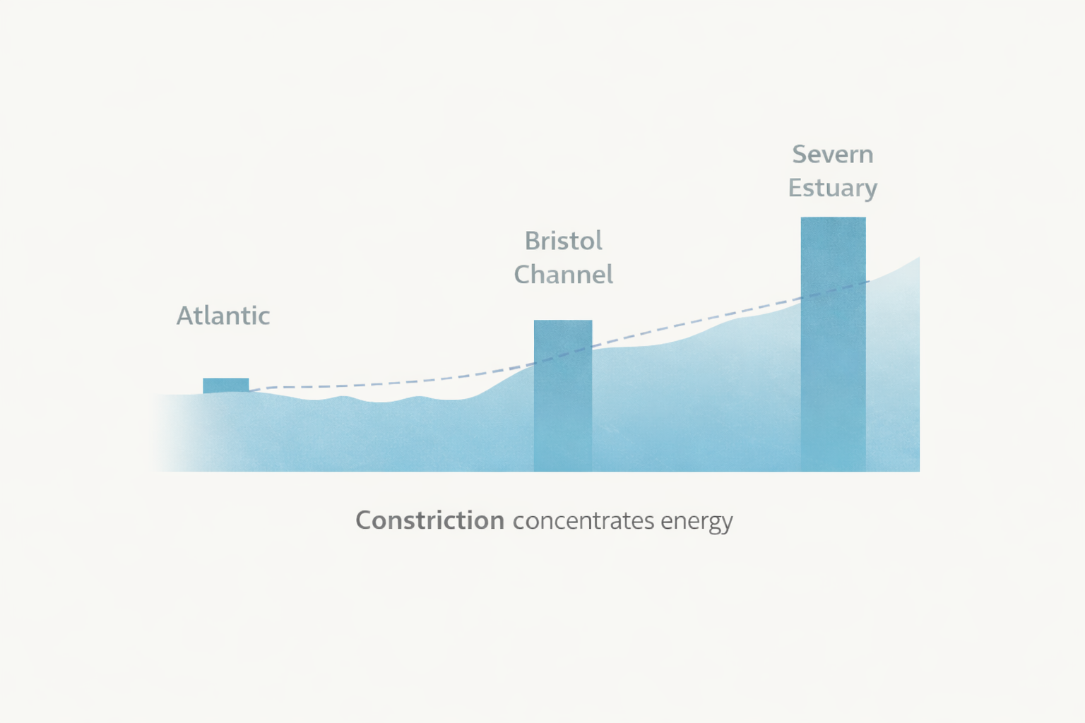
The Bristol Channel begins wide, open to the Atlantic. As it moves eastward, it narrows steadily toward the Severn Estuary. At the same time, it becomes progressively shallower.
As width decreases and depth shallows, the same volume of water expresses its energy as height rather than spread.
Those two features — narrowing width and decreasing depth — are crucial.
In open ocean, tidal energy spreads across a broad surface. The vertical rise and fall of the tide is moderated by space. As water moves into a narrowing estuary, that same volume must pass through a smaller cross-sectional area. It cannot spread sideways as easily, so the energy is expressed increasingly as height.
Nothing explosive occurs.
Nothing needs to.
The tidal range increases progressively as the estuary tightens. This is why the Severn Estuary today has one of the highest tidal ranges in the world.
Under ordinary conditions, this produces dramatic but predictable tides. The coastline has long lived with them.
But 1607 was not ordinary.
Storm Surge
Winter Atlantic storms are capable of pushing additional water into the Channel. Strong westerly winds drive water eastward. Low atmospheric pressure allows sea level to rise slightly beneath the storm system. Waves ride atop an already elevated surface.
This is known as storm surge.
Storm surge is not a single towering breaker. It is a sustained elevation of water level combined with energetic surface motion.
When surge enters a funnel-shaped estuary, the effect compounds. Elevated water moving into a narrowing, shallowing basin is progressively amplified.
The sea does not need to leap like a wall.
It only needs to arrive already raised.
Spring Tide Timing
The flood occurred near the end of January, at a point in the lunar cycle close to spring tide.
A spring tide does not refer to the season. It describes the alignment of the Earth, Moon, and Sun. When the gravitational pull of Moon and Sun combine, high tides are higher and low tides lower. The tidal range increases.
In a coastline already predisposed to amplification, this matters enormously.
Under normal conditions, spring tides are expected. Coastal communities know their rhythm. But if an elevated storm surge coincides with a spring high tide, the water level at peak can exceed the threshold of embankments and natural barriers.
The tide does not merely rise to its usual high point.
It rises beyond it.
That timing is significant. It aligns more closely with a tidal and atmospheric explanation than with sudden seismic displacement.
It does not prove the cause definitively. But it strengthens the storm-surge model considerably.
Why Somerset Bore the Brunt
At this point, geography determines outcome.
On the Welsh side of the estuary, land rises more quickly inland. Although low-lying areas such as the Gwent Levels were flooded, higher ground begins not far from the shore. Rising terrain limits how far water can travel inland.
On the Somerset side, the situation is different.
The Somerset Levels are a broad, low floodplain — historically marsh, gradually drained and reclaimed. Much of it lies only marginally above sea level. When elevated tidal water overtops embankments or breaches weak points, there is little immediate topographic resistance.
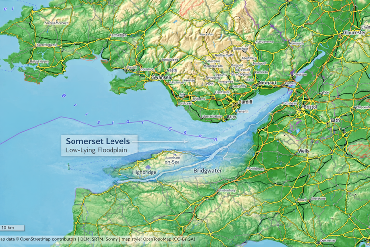
Water on flat land does not climb.
It spreads.
And where land remains flat for miles, spreading becomes distance.
Wales absorbed force against rising ground.
Somerset absorbed volume across open plain.
The distinction is geomorphological, not national.
Structural Consequence
Understanding the mechanics of water movement helps us return to the human accounts with clearer eyes.
When rapidly advancing water moves across already saturated ground, it does more than flood. It alters the stability of the land itself. Soil that has absorbed weeks of winter rain can lose cohesion under sudden hydraulic pressure. Channels overflow. Ground softens. Foundations shift.
In low-lying terrain, this process does not require a towering breaker. It requires momentum and duration.
Timber-framed buildings of the early seventeenth century, even when well constructed, depended on stable footing. Wattle-and-daub walls, timber posts, and shallow foundations could withstand wind. They could withstand seasonal damp. What they could not withstand was ground that ceased to behave as ground.
If the supporting earth becomes saturated and begins to scour or liquefy beneath sustained flow, the structure above is compromised. Collapse may follow not from impact, but from undermining.
Seen in this light, the record of James Ffroste’s house “falling down upon them” is not an image of a wave lifting a building whole and casting it aside. It is a quieter, more brutal failure — the earth itself giving way.
A towering wall of water is not required.
Destabilised ground is enough.
The violence lies not only in height, but in sustained force acting upon unstable terrain.
What 1607 Likely Represents
When we combine:
• A narrowing estuary
• Shallowing depth
• Storm-driven surge
• Spring tide alignment
• Extensive low-lying floodplain
We have a coherent physical model capable of producing widespread inundation without invoking deep-ocean seismic displacement.
To those living through it, the experience would have felt extraordinary — perhaps even otherworldly.
But extraordinary does not necessarily mean unnatural.
Sometimes disaster is the product of ordinary forces aligning under particular conditions.
And the Bristol Channel, by its shape and tide, is predisposed to amplification.
Returning to James
Now that we understand how the sea may have behaved, the entry in the parish register reads differently.
James Ffroste. Two children. His house collapsed.
It is easy to glide past those words. They are brief. Administrative. Almost restrained.
But behind them lies something immediate.
A home that had stood through previous winters.
Ground that had always held.
A family who likely believed they had time.
We do not know the exact sequence. Whether the water came first and the structure followed. Whether soil softened silently before giving way. Whether they climbed higher and hoped the surge would slow.
What we do know is that the register records structural loss. That detail anchors the event in lived reality.
For James, this was not a debate about tsunami or surge.
It was not geomorphology.
It was not tidal amplification.
It was the sudden collapse of certainty.
And he was not alone.
Widening the Lens
The 1607 inundation reached communities across both sides of the Bristol Channel and along the Severn Estuary.
Printed pamphlets of the time — including Lamentable newes out of Monmouthshire (1607) — preserve fragments of human impact, particularly on the Welsh side of the water. They name individuals not as statistics, but as neighbours caught in something larger than themselves.
Mistresse Van is described as being overtaken by water despite living several miles inland — a detail that captures how far beyond expectation the flood reached.
Mistresse Mattheus of Llandaff is said to have lost four hundred English ewes. That number alone speaks to scale. Livestock were capital, inheritance, security.
The same pamphlet names Lord Herbert, son and heir to the Earl of Worcester, and Sir Walter Mountague as coordinating boats and relief in the affected districts.
These are vivid details. But they are fragments, not full stories.
Most of the affected remain unnamed.
On the Somerset side, the record is quieter. There are no surviving pamphlets describing villages on the Levels in the same narrative form. Instead, we find parish registers — in Barnstaple, in Huntspill, in Brean — where burials cluster in the weeks following the flood, recorded without commentary.
The difference lies not necessarily in impact, but in preservation.
Pamphlets were urban products, printed where presses, patrons, and commercial markets existed. Rural communities left fewer printed accounts, but their registers were mandatory and carefully kept. What endures in the archive often reflects networks of print and survival rather than the true distribution of suffering.
A pamphlet here. A parish entry there. A name caught in ink while hundreds of others dissolved into anonymity.
And sometimes, instead of ink, memory settles into stone.
Kingston Seymour — Memory in Stone
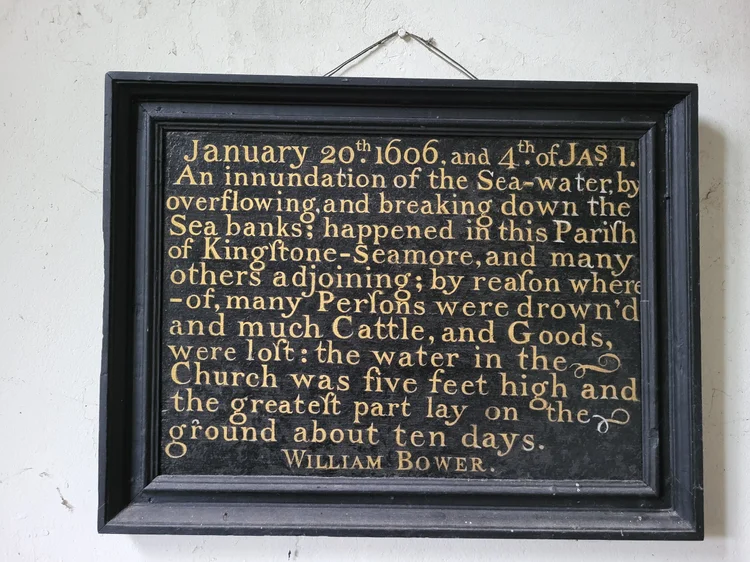
The Kingston Seymour plaque records the height and duration of the 1607 flood — not as legend, but as measurement.
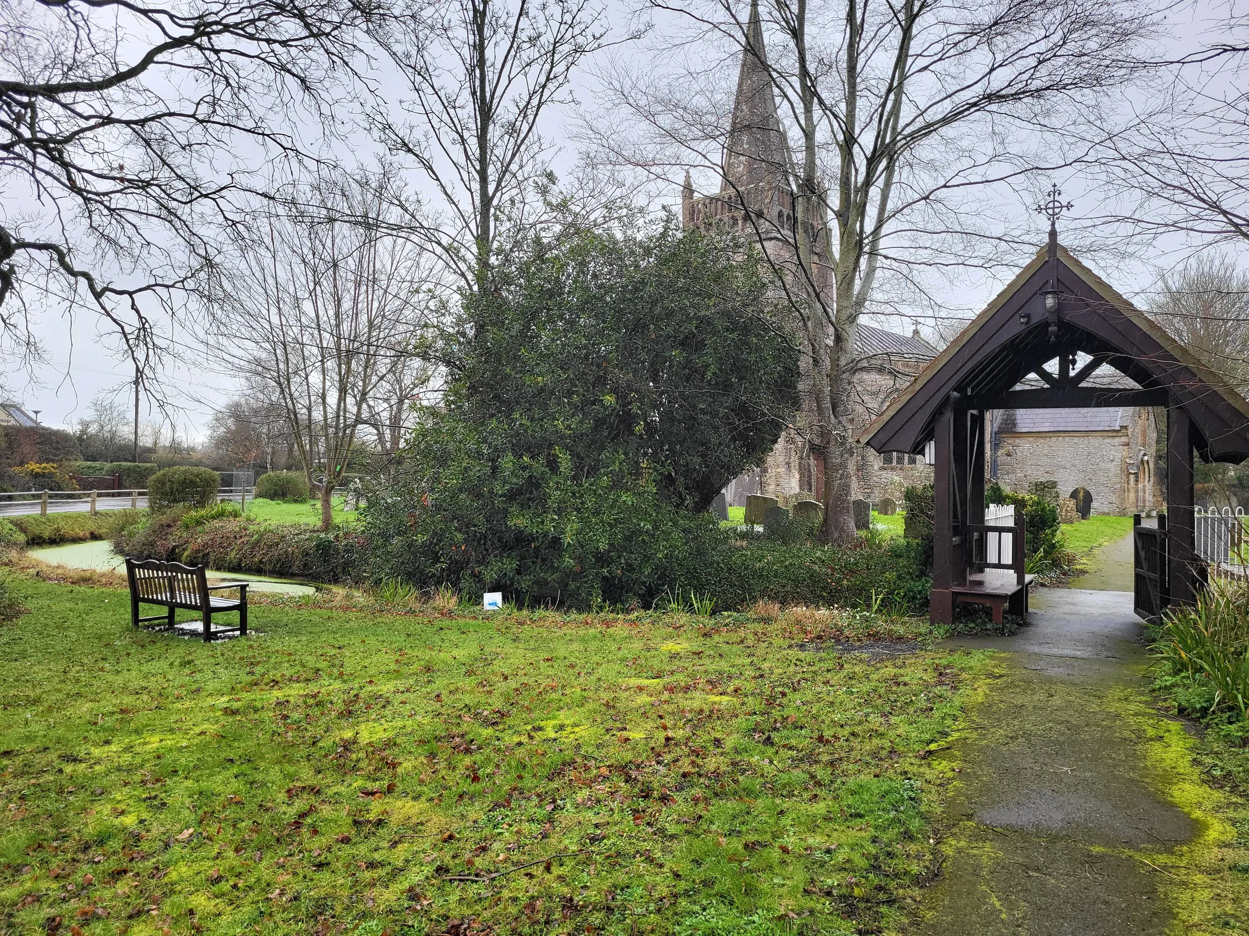
All Saints Church, Kingston Seymour. Drainage channels still trace the low ground around the church — a reminder that memory here is embedded in landscape as much as stone.
At Kingston Seymour, memory did exactly that.
I stood inside the Church of All Saints on a quiet morning and read the brass plaque fixed to the wall. It records the 1607 flood and names William Bower, preserving in metal what the water once tried to erase. The inscription speaks plainly. No drama. No speculation. Only height, duration, and loss.
Accounts suggest the water reached approximately five feet within the church and lingered for days.
Five feet inside a church.
That detail fixes abstraction into scale.
Standing there, I tried to imagine it — water against stone columns, against pews, against the very floor where generations had stood. The building today feels solid, anchored. But five feet is not a damp winter. It is not surface pooling in a churchyard. It is immersion.
I searched for the physical flood mark itself. Some accounts describe a visible indicator within the church. If it is there, I did not see it. That absence may say more about me than about the building. Marks fade. Eyes overlook. Memory shifts from stone to plaque, from physical trace to inscription.
But whether visible in masonry or preserved only in record, the testimony remains:
The water came this far.
Outside the church, the land offers little resistance. Apart from the motorway bridge rising above the plain, there is scarcely any natural high ground. The horizon is wide and level. It does not take much imagination to picture the surrounding fields filling, the lanes disappearing, the building becoming an island.
A drainage ryne runs through the Levels nearby — part of the long human effort to manage water here. Whether its present form existed in 1607 or developed later through centuries of drainage and reclamation, it tells a consistent story: this is negotiated ground. Water is channelled, redirected, persuaded.
But persuasion is not control.
Churches in early modern England were not incidental structures. They were the centre — spiritual, social, administrative — of parish life. To flood a church was to flood the heart of a parish.
And Kingston Seymour is not unique. Other churches along the estuary preserve similar marks or records.
These are not metaphors.
They are measurements.
Whether visible in stone or preserved only in inscription, they fix the event in place.
Not legend. Not exaggeration.
Simply water — recorded at a height no one expected.
The Tide Still Rises
It is tempting to imagine that events like 1607 belong to a distant, less sophisticated world — a time before engineering, forecasting, and flood defences.
And yet, the Somerset Levels have flooded in living memory.
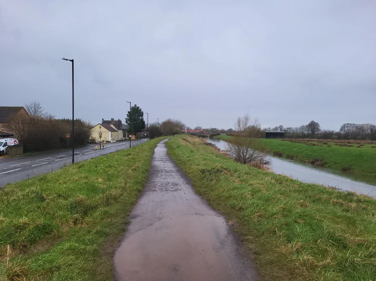
I have stood between the River Yeo and the A370 after weeks of winter rain and felt how little separates road from river. The flood banks rise higher than the carriageway. The water level sometimes appears uncomfortably close to their crest. It does not take much imagination to picture those embankments gone — and the flat land between Weston and Congresbury returning to what it once was.
Driving inland toward Crook Peak, the pattern becomes clearer still. The older farmhouses and cottages are not scattered randomly. They climb the slope. They settle against rising ground. The villages cling to elevation where they can. The flat expanses below — wide, open, apparently convenient — were once marsh.
Perspective changes understanding.
From the Mendip slopes, the Levels look almost infinite in their flatness. The horizon stretches unbroken until it meets distant hills — Exmoor faint beyond the curve of the world. Much of this land lies only a few metres above sea level. It appears solid. It is productive. But it remains negotiated ground.
In recent years, prolonged winter rain and high tides have again turned fields into water. Roads have closed. Homes have been evacuated. Arguments have resurfaced — about dredging, about embankments, about responsibility.
The language has changed. The mechanisms have not.
Water still follows gravity.
Estuaries still amplify.
Flat land still spreads what it cannot resist.
What differs is expectation.
In 1607, communities negotiated with water because they had no alternative. They repaired, they rebuilt, they recorded. Relief came from those close enough to row.
Today, we expect structures — literal and administrative — to hold back the tide. When they fail, frustration rises quickly. Questions are asked about funding, policy, prevention.
Some of those questions are necessary.
But 1607 reminds us of something older than policy.
Nature is not defeated. It is managed, temporarily.
The Bristol Channel has not changed its shape. The Severn Estuary has not reduced its tidal range. The Levels remain flat.
If a storm surge aligned with a spring tide tomorrow as it did then — and if defences failed or were overtopped — the consequences would not feel medieval. They would feel immediate. Modern infrastructure would not float any better than timber frames did in 1607.
The difference would lie in scale — not in principle.
Because coasts remember.
Not in myth alone, nor in dramatic language, but in marks on stone, in inked parish entries, in embankments built higher than the road beside them, in farmhouses positioned just above the line where water once spread.
The debate over tsunami or storm surge matters. Accuracy matters. Understanding the mechanics matters.
But perhaps what matters more is recognising that this coastline has always lived with amplified water — and always will.
Disaster becomes legend when explanation fades.
Memory becomes useful when it informs how we live with risk.
The sea did not change in 1607.
It behaved according to its shape and its tide.
What changes is how we interpret it.
And whether we remember.
When we read a name in a parish register, we see only what ended.
What we do not see are the continuations that never came — children who would have grown into trades, fields that would have been tended by another generation, knowledge passed from parent to child and then lost in a single tide.
Disaster does not only take lives. It interrupts futures.
And memory is not simply about looking backward. It is about carrying forward. Recording. Questioning. Marking the waterline before it fades. Ensuring that the names written in ink — and the lives we live now — are not reduced to footnotes when the tide recedes again.
Download this essay